Drone Mapping

Drone Mapping, A Modern Tool

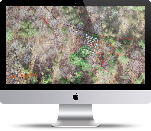
Recon Aerial specializes in drone mapping services and aerial drone surveys to create various outputs for civil and road works, drone rail inspections, power and utility planning, energy infrastructure planning, slope analysis, mining and aggregates,  land-use management, biological surveys and environmental surveys, property development, urban planning, commercial real estate and information for many other sectors and purposes.

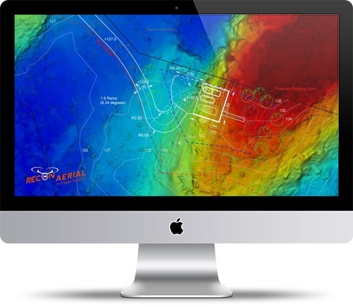
The direct file exports from our drone mapping/photogrammetric software include 3D model (.obj), point cloud (.las), elevations contours 1,2,3,5 feet (AutoCAD, .dxf), and a geo-referenced orthomosaic.

drone mapping image recon aerial

Drone mapping and surveys, are incredibly valuable as a planning tool and are increasingly being used by engineers, architects, planners, and project managers to enhance their awareness of a property, to plan and add value to their work. The power of aerial drone mapping and surveying lies in the valuable data produced. Drone data provides a comprehensive visual representation. Traditionally survey techniques are slow and are considerably more expensive. Though these techniques produce accurate, detailed information, the purpose of a traditional survey is to act as a reference point, not to provide data for advanced integration into BIM, AutoCAD, and similar 3D modeling software suites.

Drone Mapping & Site Planning

Drone Mapping Project Description

The 3D point clouds shown above were developed from 4 separate mapping projects. They demonstrate ou capability to deliver on complex projects.

Once we conduct a mapping mission or aerial drone survey to gather the required data we output a 3D model, point cloud, elevation, and digital terrain model. Using the drone survey data we can create site plans and AutoCAD/PDF exports that incorporate site features, roads, setbacks, property lines, etc as overlays.

Though the result of processing and manipulating drone data and land-based survey data is not a legal survey, that’s not the point…it’s actually much more powerful.  More powerful because the drone data exports can be incorporated into existing architectural and engineering workflows.  It’s an extraordinary useful information set. Our mapping data has been used by clients to build in conformance with condominium agreements, to plan site activities, and submitted to municipal building authorities for zoning/rezoning applications and more.

recon-aerial-line work from drone data dwg-autocad-files residential development recon-aerial-dwg-autocad-exports-and-processing

Property Design, Planning & Construction - Added Value

Recon Aerial was tasked with conducting a drone mapping and surveying mission to assist an architectural firm in placing a home on a 10 ace, waterfront lot. Recon flew 3 flight missions at 170, 220, and 250 feet over 2.0 hrs taking approximately 800 images at various GSDs. In addition, Recon took still images and video, separate from the mapping mission, to provide greater detail about the natural features of the site.  The site was obscured by trees and with considerable elevation changes.

Traditionally, the architect/planner may need to visit the building site several times to ensure the proper placement of the dwelling in relation to setbacks, the elevation profile, property lines, sight-lines, access to the waterfront, etc, not so in this case.

Recon Aerial flew the property once and provided the standard drone mapping and aerial survey data package. The architect used the data to produce the planning exports seen below. According to the architect, the data was pivotal in allowing them to fully understand the site details, place the home correctly in relation to the natural site features and meet their clients’ constraints in relation to the build and to the covenants held with the purchase agreement.  In fact, additional planning in relation to a road was required given the substantial elevation changes revealed via the aerial drone survey.