CONSTRUCTION DRONE SERVICES
DRONE CONSTRUCTION MONITORING
Construction project monitoring by drone is important because it cuts project evaluation time, allows project managers to better predict problems before they occur, and helps keep projects on schedule. Project managers can quickly control and confirm work completion.
DRONE CONSTRUCTION PLANNING
Construction planning using UAVs is important because it saves time and produces excellent repeatable data that can be used to improve project delivery. Site features can be extracted, overlaid on top of a georeferenced site photo, and incorporated directly into an AutoCAD workflow.
DRONE CONSTRUCTION INSPECTIONS
Construction inspections using UASs are important because they complement existing inspection regimes improving data capture. The operation of a UAV makes inspections many times faster, but also produces data that on its own is valuable but that can be aggregated to provide great insight.
Drones For Construction Managment
Construction Drone Managment
Many construction companies projects can benefit from the use of drones. Generally, drone data is more useful for larger projects like roads, railways, bridges, dams, and utility projects. However, even small-scale land development projects can benefit from the highly accurate drone construction data.
Drones in the construction industry are used for surveying, volumetric analysis, site planning, 3D modeling, digital elevation modeling, orthomosaics, equipment tracking, security, worker safety, inspections, project monitoring. UAV data is also widely used as a communication and collaboration tool on construction projects.
UAVs are readily accessible to construction professionals who want to work smarter, faster, and save money. Drones are a practical tool and add great value to sites.
Many construction companies projects can benefit from the use of drones. Generally, drone data is more useful for larger projects like roads, railways, bridges, dams, and utility projects. However, even small-scale land development projects can benefit from the highly accurate drone construction data.
Drones in the construction industry are used for surveying, volumetric analysis, site planning, 3D modeling, digital elevation modeling, orthomosaics, equipment tracking, security, worker safety, inspections, project monitoring. UAV data is also widely used as a communication and collaboration tool on construction projects.
UAVs are readily accessible to construction professionals who want to work smarter, faster, and save money. Drones are a practical tool and add great value to construction sites.
The integration of 3D construction site models into various building information management (BIM) software suites like Autodesk Revit and Navisworks can act as a second set of eyes for clash detection/plan to actual verification. This is just one benefit of drones used in the construction process.
Many clients are now conducting autonomous flights over their sites on a weekly basis in order to create orthophotos. These orthophotos allow the project manager to see the entire site on large warehouse construction projects. It allows them a summary view of the project and services as a documented recording to prevent costly slowdowns. There are many uses for UAVs on construction site. Recon Aerial offers all drones services but we see drones adding a great deal of value for Construction companies in Monitoring, Planning, and Inspections.
Constructions Monitoring
One of the most common uses to date for unmanned aerial vehicles on construction sites is for project monitoring. UAVs can provide immediate feedback in second that details construction progress in a way not previously possible. There is really no limitation to the size of the site large or small that can benefit since images can be stitched together to create one contiguous picture.
Regular project tracking via aerial drone imagery combined with visual design and construction methodologies allows enhanced project quality control. The more information a project manager has to make decisions, the better those decisions will be, and better decisions often mean lower project costs and on-schedule delivery.
Constructions Planning
Construction site management that utilizes unmanned aerial vehicles takes advantage of innovative technology and brings an aerial perspective into site inspection, design, and is very important to the planning phase of project implementation.
Construction drones data can be used in common CAD software to model, plan, measure, and predict issues before they become a real-world, costly challenge. Simply having access to site elevation data can have a huge impact on the timing of a project, where equipment can be placed on-site, and may even impact the order of operations.
Did you know that we can measure site features with a relative accuracy of about 1 inch for a flight flown at 215 feet with the M300/P1 combo!
Constructions Inspections
In addition to project monitoring, unmanned aerial vehicles can be used more specifically for construction site inspections. Drones can be used to inspect the exteriors of building inspections, bridges, towers, roofs, and similar elevated assets at a fraction of the cost of manned inspections, much faster and they are a much safer alternative.
In short, sUAS routinely gather a wealth of information using zoom RGB cameras and even thermal cameras.
Importantly, documented visual records offer a burden of proof for construction managers for construction handovers but may also prove invaluable to settle disputes related to delays, change orders, reworking, etc., for ongoing works.
Additional Uses & Advantages of Using Drones in Construction
3D Modelling using Drone Data
In general terms, 3D models are dynamic imaging data that can be manipulated to view construction sites, bridges, buildings, or any scene/area of interest from any angle of your construction site.
3D modeling in architecture and design has been around for many years. However, modeling using UAV data has been limited until fairly recently. It’s been limited because drone technology and processing software were either too expensive or not up to the task. Now, the accessibility of drones and sophisticated photogrammetric software has made it possible to model and map large scenes.
Geo-referenced 3D point cloud data can be integrated as files into programs like Autodesk Recap, Revit, Navisworks, Infraworks, and others allowing for advanced manipulation, measurement, inspection, confirmation, collaboration, planning, and design.
Orthomosaic Site Mapping for Construction
Orthomosaic site mapping is an interactive and geometrically corrected map made from aerial imaging. Depending on the map size it can be made of 100’s of drone images that are stitched together. Orthomosaics give look like a google map made from satellite data but they are far more detailed and can be made far more accurate. With our drone technology and according to the manufacturer our aerial mapping projects are accurate to 3-5cms in the XYZ. Better still, using survey receivers as a base and rover we can incorporate ground control points making orthomosaic maps of construction sites even more accurate.
Drone maps provide our clients the ability to manipulate the data to facilitate construction project management. For example in road construction, we can overlay the CAD info on the orthophoto. Doing this we can compare the actual or “as-built” vs the design. This allows construction project managers to verify work completed and correct oversights.
2
Orthomosaic Mapping for Construction Sites
Orthomosaic Mapping for Construction
Orthomosaic site mapping is an interactive and geometrically corrected map made from aerial imaging. Depending on the map size it can be made of 100’s of drone images that are stitched together. Orthomosaics give look like a google map made from satellite data but they are far more detailed and can be made far more accurate. With our drone technology and according to the manufacturer our aerial mapping projects are accurate to 3-5cms in the XYZ. Better still, using survey receivers as a base and rover we can incorporate ground control points making orthomosaic maps of construction sites even more accurate.
Drone maps provide our clients the ability to manipulate the data to facilitate construction project management. For example in road construction, we can overlay the CAD info on the orthophoto. Doing this we can compare the actual or “as-built” vs the design. This allows construction project managers to verify work completed and correct oversights.
Construction Surveying
Drone surveying is the evolution of drone mapping. Surveying though not technically surveying given the limitations of the technology is still incredibly useful AND accurate.
Surveying by unmanned aerial vehicles involves flying and creating a highly accurate orthomosaic. This map is made more accurate by deploying typical survey equipment ground control, a rover, and a base station, to take ground control and checkpoints making your site documentation a lot more accurate than traditional methods.
Ground control is brought into the mapping process and allows us to create maps that are absolutely accurate to <5cm in the XYZ. This means that manholes, paint striping, utilities, building, and other site features can be accurately overlaid on the site map. This provides better, more detailed information than simple linework since it offers an amazing visual real time progress representation of the construction site.
Pre Construction Plans
Construction drones can help you trace dangerous, complex or undocumented areas in a matter of minutes. Utilize cameras on drones to get high-quality drone images of particular regions. These photos can be distributed to key stakeholders or investors to better understand the scope of the project.
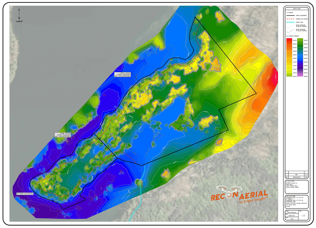
Integration with drone mapping programs can aid your team in creating Contour Maps to better understand the current topography of your site. Fly your drone using the grid of a prefixed grid and create Digital Surface Models of your entire site. Pre construction Drone Orthomosiac mapping can improve the precision and authenticity of your design plans making use of your own orthomosaic image as the background.
4
Pre-Construction Planning
Pre Construction Plans
Construction drones can help you trace dangerous, complex or undocumented areas in a matter of minutes. Utilize cameras on drones to get high-quality drone images of particular regions. These photos can be distributed to key stakeholders or investors to better understand the scope of the project.
Integration with drone mapping programs can aid your team in creating Contour Maps to better understand the current topography of your site. Fly your drone using the grid of a prefixed grid and create Digital Surface Models of your entire site. Pre construction Drone Orthomosiac mapping can improve the precision and authenticity of your design plans making use of your own orthomosaic image as the background.
CAD Overlays on Drone Photos
Using commercial drone imagery to overlay CAD design data analysis is an exceptionally valuable tool during the construction process. Doing so allows construction managers to compare as-built drawings with design documents to ensure the construction aligns with the design intent. This simple exercise can prevent $1000’s or even $100,000 of dollars in costly rework.
A practical example: The image here shows a casting slab used in the pre-fab construction of a 6 story hotel. Recon Aerial flew the slab mapping it with a drone, stitched the images, and inserted a scaled design document on top of the panels to check the dimensions. If the walls were incorrectly measured or constructed and subsequently lifted into place, the tie-in points would not have lined up and this would have cost $1,000s in additional man-hours and equipment rental.
As-built to design comparisons using drone data can be used to prevent costly mistakes.
Drone In Constructions Safety
The top priority for any construction company is the safety and health of its employees, Utilizing drones during the planning of construction sites and beyond minimizes the risks that employees face during surveys and inspections. Accidents can happen in any field of construction. With drones in your construction team, they are less likely to happen.
Construction is defined by low margins. Innovation, implementing more efficient workflows, and utilizing the latest technologies are all essential to surviving.
The use of drones to locate work areas is a technological advancement that rapidly will pay for itself, and there is no way to place a price on the safety culture improvement which comes with flying robots being put in danger instead of humans and especially builders.
Inspection Efficiency
The safety of your workplace requires a thorough inspection of any potential hazards. drones can perform the required inspections without putting human inspectors in danger. Drones are able to provide high-quality images to evaluate conditions in a safe and secure place.
Drones permit thorough inspections, and inspectors aren’t at risk of being exposed to dangerous conditions. Drones can help prevent job site falls, slips, and other injuries that may happen when workers attempt to navigate hazardous areas on the job site.
Accident Prevention
Drones offer a proactive method to enhance safety at sites. One of the main benefits of drones is their capability to observe massive construction sites.
UAVs that are equipped with infrared cameras and radars or laser-based range finders are able to provide precise images of a location and be able to closely track moving objects like equipment, people, and even materials. That information will help managers of the site to identify safety concerns as well as save time.
Drones In Maintenance Safety
When drones are able to replace humans as inspectors they instantly enhance the safety equation, Carrying out reactive or planned maintenance inspections of structures that are high up such as bridges towers, roofs, and scaffolding with up to date data often requires expensive access arrangements, as well as employees working on-site working at heights.
Drones on the other hand are a more efficient method to carry out inspections and transmit HD footage live to the inspector or engineer at ground level.
Construction Site Aerial Photography
Great aerial imaging using drone camera features in construction photography is only part of the solution but it’s a highly effective way to make your presence known and to keep your construction company name front and center with your clients.
Images sell. Your marketing efforts will improve immensely when you add drone construction photography to your website, social media accounts, brochures, and project examples. One of the best uses of drone imagery on construction projects is to show weekly or monthly progress updates to owners. Owners are very impressed by image-based updates because it’s immediate visual feedback, they can see firsthand what’s going on.
Drone aerial images also make it easier to collaborate with all stakeholders and tackle specific issues because it’s easy to see what’s happening in a drone camera image or video without being on-site.
Drones For Constructions Marketing Growth
Drones For Constructions Marketing Growth
Why use drone video to market yourself within the construction industry? Because drones offer a unique aerial perspective and are able to highlight your project in a unique way. You will set yourself apart! Local construction industries are tight-knit communities, expertise is often held by relatively few individuals or companies and because of this work often finds you. This works well when the market is booming but what happens when things slow down?
Marketing is not about getting the next job, it’s about growth and position. When things slow down and market share is restricted, having an established presence better than your competition can keep you at the top of people’s minds for new projects.