
...

Get in Touch!

We would love to hear about your project. It's easier than you think and you will be impressed with the results!

Contact Info

  • Ottawa, Headquarters
  • info@reconaerialmedia.com
  • Week Days: 09.00 to 17.00

Toronto Drone Services

Recon Aerial > Toronto Drone Services
Toronto Drone Company

Toronto Drone Services Company

High Quality Aerial Services, Just Say Go!

Looking for a Toronto drone services company you can actually count on? Recon Aerial has a Transport Canada advanced operations pilot based in Toronto, so we can typically be on site across the GTA within a few days. Exact timing depends on the project: sites inside Toronto Pearson’s controlled airspace need NAV CANADA approval, and larger jobs need more planning.

At Recon Aerial, we offer professional drone services that check all the boxes: high-quality results, reliable execution, and great value for your investment. Whether you need crisp aerial photos, smooth cinematic video, detailed mapping, or complex inspection work—we’ve got the experience and gear to make it happen, and make it look amazing.

We’ve been flying drones across Ontario for years, and we know Toronto like the back of our hand. From downtown construction sites to sprawling real estate developments and everything in between, our team knows how to capture the perfect shot while staying 100% compliant with all Transport Canada regulations.

Our drone pilots are fully certified and insured, and we bring a “no corners cut” mindset to every single project. We don’t just show up with a drone—we show up with a plan, the right equipment, and a commitment to getting it right the first time.

What sets us apart? It’s simple: we deliver premium results without the premium attitude. We’re easy to work with, fast to respond, and focused on making your project shine—on time, and on budget.

So, whether you’re a builder, a real estate agent, a filmmaker, or a business owner looking for that standout aerial perspective, Recon Aerial is the Toronto drone company that’s ready to help you elevate your vision.

Let’s take your project to new heights—literally. Contact us today and let’s make something awesome together!

Brian Stoneman, President of Recon Aerial

Brian M. Stoneman

President, Recon Aerial
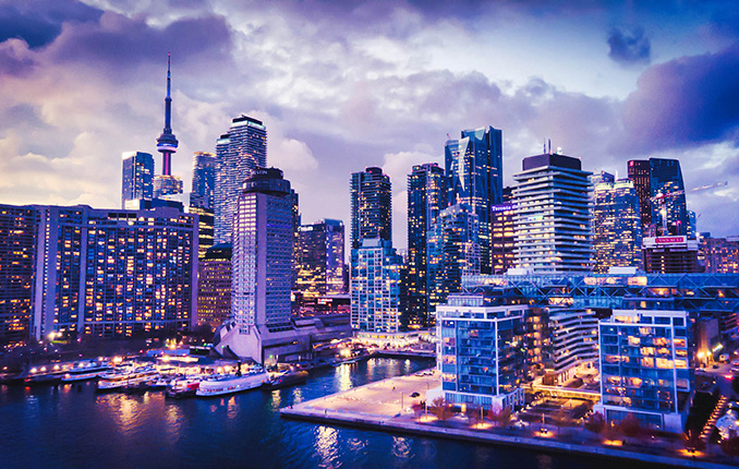
Toronto Skyline at Blue Hour drone services

10

+
Years Of Experience

10

+
Years of experience
Toronto Skyline at Blue Hour drone services

Recon Aerial delivers expert drone imaging, inspections, mapping, and construction support with precision, reliability, and value—making us the smart, trusted choice for your needs.

Want to Know More? A Few Drone Services


Our Toronto drone services include:

Toronto Projects

Recent Drone Projects in Toronto and the GTA

Here are four recent drone projects across Toronto and the Greater Toronto Area, with the real scope, results and deliverables for each. Every project is planned around the site’s airspace, access and safety requirements, including NAV CANADA approvals for sites inside Toronto Pearson’s controlled airspace.

city of vaughan drone construction progress photos
Construction Progress Imagery, City of Vaughan Community Centres
For more than four years, the City of Vaughan has relied on us to document construction at multiple community centres. We fly each site on a repeating schedule, capturing consistent high-resolution imagery from the same positions so project teams can compare progress over time. The work is ongoing.
  • Municipal client, multi-year engagement since 2021
  • Repeated high-resolution imagery from consistent vantage points
  • Progress documentation for project teams and stakeholders
drone mapping project king city ontario
Survey-Grade Drone Mapping, King City
R.J. Burnside, an engineering consulting firm, needed accurate site mapping in King City. We delivered georeferenced mapping backed by ground control points, along with layered AutoCAD planimetric drawings ready for their engineering team to use.
  • Georeferenced imagery backed by ground control points, with raw GCP and accuracy data
  • Layered DWG planimetric drawings, with and without orthomosaic backing, plus PDF drawings
  • Orthomosaic, 3D mesh, point cloud, classified LAS, DSM, DTM and contours
  • Clean Top TIN
roof inspection project image in brampton ontario on bramsteele road
Commercial Roof Inspection, Brampton
The owner of a commercial building in Brampton needed a clear record of their roof’s condition without sending crews up top. We captured high-resolution inspection imagery and video of the entire roof system, giving them the documentation to plan maintenance.
  • High-resolution inspection imagery of the full roof system
  • Inspection video for review and records
  • No roof access, lifts or crews at height
lakeshore toronto commercial real estate project image
Commercial Real Estate Photography for Trinity
Trinity uses our aerial photography to promote properties across the GTA. We capture each property and its surroundings from the air, producing imagery for listings, marketing materials and promotional media.
  • Aerial photography across multiple GTA properties
  • Imagery for promotional and marketing media
  • Property context: access, surroundings and nearby amenities
Quality Results

What We do For You?

High Quality Aerial Services, Just Say Go!

If you’re searching for a reliable Toronto drone company to capture stunning drone photos or video for your next project—you’re in the right place. At Recon Aerial, we’re all about delivering top-quality aerial media that helps your project stand out.

We make the process easy. Fast responses, efficient planning, and quick turnarounds are just how we roll. Most of our drone flight operations are wrapped up within a week—and in many cases, clients get their edited drone photos or videos as early as the next day via courier or digital transfer.

We shoot with quality in mind, every time. Our drone photos are taken in RAW format (16:9, 4:3, or 3:2), giving you plenty of flexibility in post-production. As for video? We typically shoot in crisp 4K at 24 to 60 frames per second—unless your project calls for something different. We tailor everything to match your vision.

What’s the end result? High-quality aerial visuals you can use just about anywhere: brochures, websites, social media, pitch decks, presentations, project overviews, marketing campaigns—you name it. If it needs an aerial view, we’ve got it covered.

So whether you’re showcasing a real estate development, pitching a new idea, or just want to wow your audience from above, Recon Aerial is the Toronto drone company that delivers the goods—on time, on point, and with zero hassle.

Ready to elevate your project? Let’s fly—reach out today and let’s create something awesome together!

Construction Site Video Monitoring
Value for Money

Why Choose Recon Aerial as your Toronto Drone Company

High Quality Aerial Services, Just Say Go!

If you’re looking for a Toronto drone company that delivers high-quality results, stays on budget, and actually makes your life easier, Recon Aerial is your go-to team.

We’re all about value. That means giving you the absolute best bang for your buck: professional service, stunning drone footage, and zero corners cut. Our experienced team follows all Transport Canada regulations, and we only fly with advanced-certified pilots. In fact, we’re one of the few drone companies in Canada with Flight Reviewer status, meaning we help certify the next generation of drone pilots.

We’ve worked with some big names, including Pascal Productions, Circle K, Pomerleau, Site Cast, JLL and Manulife-Colliers. So whether you’re flying over a construction site downtown, filming a commercial, or collecting data for a large-scale survey, we’ve got the skills (and the gear) to get it done right.

We’ve been flying missions across Ontario and Quebec for 10 years, with thousands of successful drone flights under our belt, including work in all classes of controlled airspace. We’re fully insured, fully experienced, and totally committed to helping your project look amazing.

No matter the industry (film, energy, real estate, construction, mapping, or more), we’ll help you capture the kind of high-quality visuals that elevate your message and give your project a real edge.

Want to see what we can do? Check out samples of our work and pricing, and let’s talk about how Recon Aerial, your trusted Toronto drone company, can bring your vision to life.

Let’s fly. Reach out today and let’s get your project off the ground!

Dependable drone services from recon aerial_750
Toronto Drone Services FAQ Mockup
Toronto FAQ

Toronto Drone Services: Common Questions

Yes, with the right approvals. Much of Toronto sits inside controlled airspace around Toronto Pearson, and the downtown core and waterfront fall within Billy Bishop Toronto City Airport’s airspace, where restrictions get tighter the closer a site is to the airport. NAV CANADA may limit altitude or add conditions for those flights. We fly under a Transport Canada advanced operations certificate, request NAV CANADA authorization for every flight in controlled airspace, and tell you up front if a site has limitations.

If there are specific conditions you regularly deal with near Billy Bishop, such as particular altitude limits or areas that are typically refused, tell me and I’ll add them. That kind of detail is exactly what shows a Toronto buyer you’ve actually flown there.

All of Toronto and the GTA, including Vaughan, Brampton, Mississauga, Markham, Richmond Hill, King City, Pickering and Oakville. Recent projects include construction progress imagery for the City of Vaughan, mapping in King City and a commercial roof inspection in Brampton.

Our pilot is based in Toronto, so we can typically be on site within a few days. Sites in controlled airspace need NAV CANADA approval, and larger projects need more planning, so tell us your deadline when you request a quote.

Edited photos and video are often delivered as early as the next day. Inspection reports and mapping deliverables take longer because of processing and analysis, and we’ll give you a delivery date with your quote.

Our services

Principal Drone Services

Aerial drone photo of the Toronto skyline
Media Capture and Production
If you can think of it, we've shot it! Movies, TV shows, documentaries, commercials, commercial real estate, backplating, 3D modelling, project briefs, pitch decks, websites, social media and post-production project videos. We love to get creative, so challenge us and see what we can do!
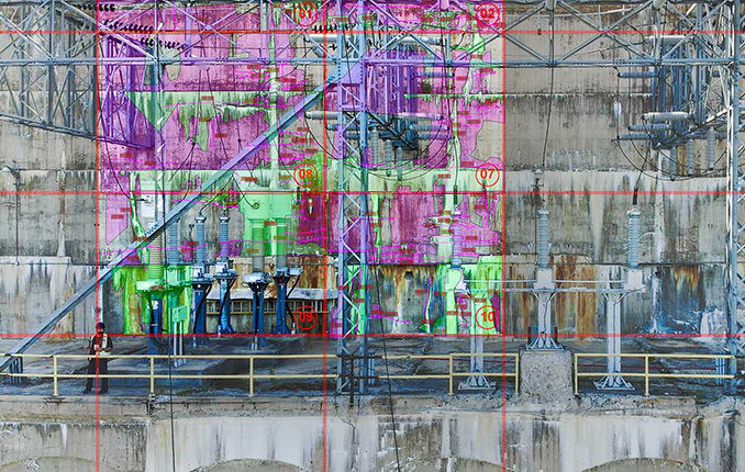
Drone inspection of critical infrastructure
Drone Inspections
We've inspected many types of critical infrastructure, including wind turbines, power lines and electrical infrastructure, building facades, bridges, cell towers, dams, railways, roofs, flare stacks and solar panels. We provide high-resolution imaging, often backed by AI, to detect damage or inefficiencies.
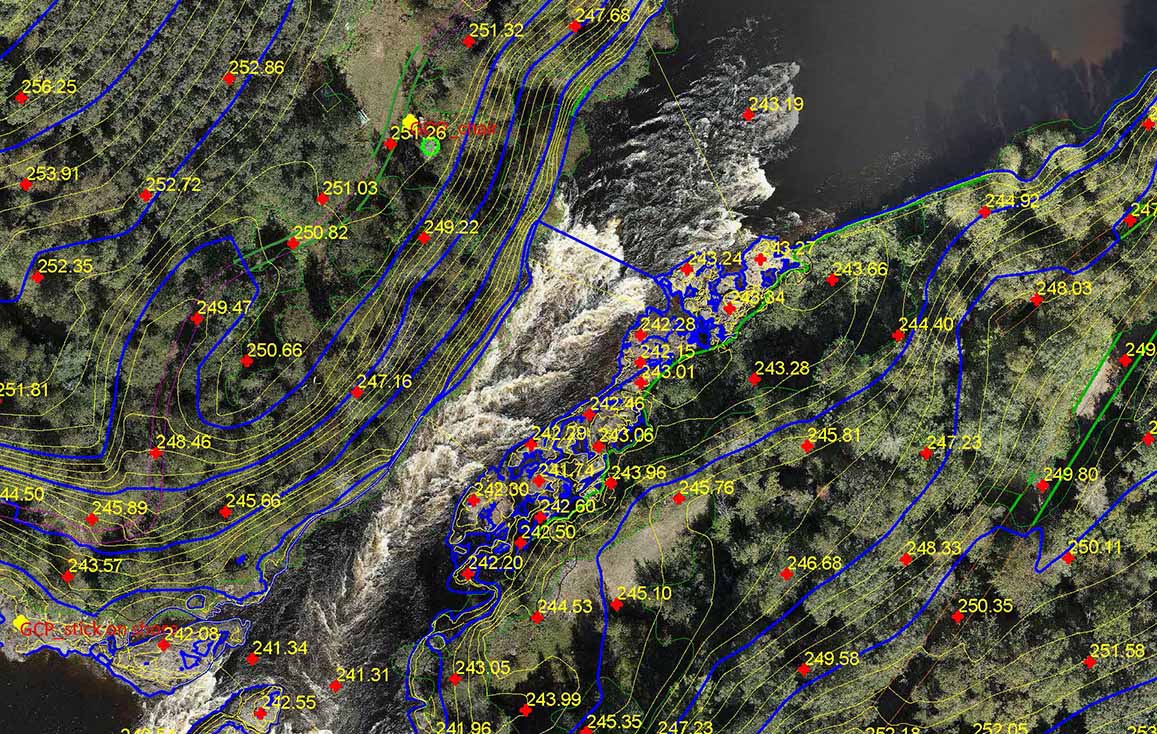
Drone mapping and surveying deliverable
Mapping and Surveying
We use the best drones and survey receivers to create highly accurate maps, and we offer a first-in-Canada Aerial-to-AutoCAD workflow. We deliver survey-grade mapping images with georeferenced linework directly to our clients' desktops. Because the linework is layered on georeferenced images of your site, it's more useful than traditional survey drawings. Just open the files and get to work!
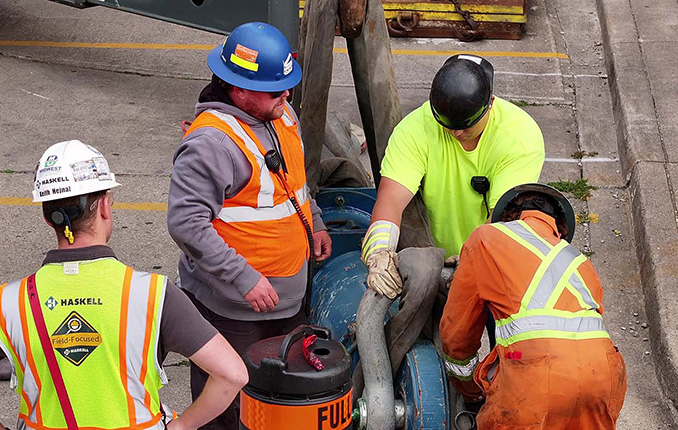
Drone services for construction sites
Construction Sites
We offer construction progress photography, site management media, live-stream timelapse services and CAD mapping. We help site staff and project managers see their site from a different perspective, which cuts down evaluation time, helps predict problems before they occur and keeps projects on schedule. Project managers can quickly confirm work completion.
Our Work

Getting it Done!

Drone services image over river 2
10
+

Years Strong

475
+

Happy Clients

Drone services image over river 3 (1)
1500
+

Missions Flown

500000
+

Kilometers Travelled