04
Apr
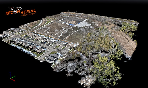
Drone Surveying
Drone surveying brings several advantages across a wide array of industries, providing a modern alternative to traditional surveying methods. These benefits include:
- Time Efficiency: Drones can complete surveying tasks much faster than traditional methods. They can quickly cover large or difficult-to-access areas, significantly reducing the time required for data collection.
- Cost-Effectiveness: Operating drones for surveying purposes can be more cost-effective compared to traditional methods. It reduces the need for multiple crews and expensive surveying equipment, and also minimizes travel and setup time.
- Enhanced Safety: Drones allow for the collection of data in hazardous or inaccessible areas without putting surveyors at risk. This includes environments such as mines, steep terrains, and areas with potential hazards like exposed wires or unstable structures.
- High Data Quality and Precision: Modern drones are equipped with advanced sensors and cameras that capture high-resolution images and generate precise data sets. This results in detailed 3D models, maps, and other forms of data visualization that provide insights with high accuracy.
- Versatility and Scalability: Drones can be used for a variety of surveying applications, from construction and mining to agriculture and archaeology. They are adaptable to different scales of projects, whether it’s surveying a small plot of land or mapping large geographical areas.
- Reduced Environmental Impact: Compared to traditional surveying methods, drones cause minimal disturbance to the surveyed land. This is particularly beneficial for sensitive environments and ecosystems, where the presence of humans and heavy machinery can be disruptive.
- Real-Time Data and Insights: Some drones offer the capability to process and transmit data in real-time, providing immediate insights that can be crucial for time-sensitive decisions and actions.
- Accessibility to Difficult Areas: Drones can easily access areas that are difficult or impossible for humans to reach, such as mountainous terrains, dense forests, and wetlands, enabling comprehensive surveying without the logistical challenges of traditional methods.
- Automated Data Collection: Many drone operations can be automated, allowing for repetitive, precise surveying without human error. Pre-programmed flight paths ensure consistent coverage and data quality across multiple surveys.
- Integration with Advanced Technologies: Drones integrate well with other cutting-edge technologies, such as GIS software, AI, and machine learning algorithms, enhancing the analysis and application of the data collected.
By combining these benefits, drone surveying not only enhances the efficiency and safety of surveying projects but also opens up new possibilities for data collection and analysis across various sectors.
Need more info? Contact Us!
0 comments